Wednesday, April 26, 2006

The Golden Gates of Kiev

What reminds you the word "Kiev"?

If you are about my age, and are a rock fan, probably the first meaning that comes to your head comes from Emerson Lake and Palmer album "Pictures at an Exhibition" itself inspited in a Mussorgsky's piano suite.

Photo 1: "Pictures at an Exhibition" album cover

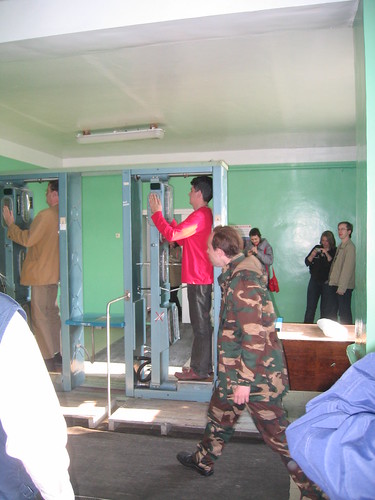
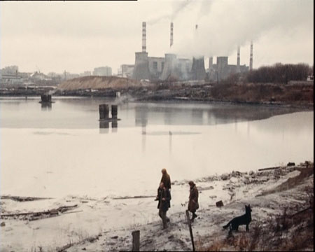
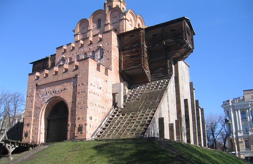
Photo 2: A (possibly inaccurate) reconstruction of the gate of Kiev

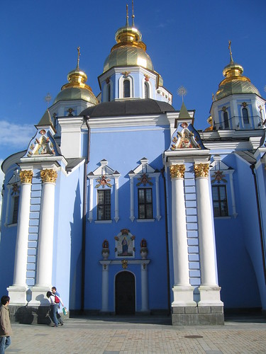
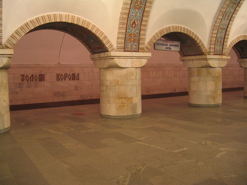
Photo 3: The nice (and depth) metro station of "Zoloti Vorota" (means: "golden gates") near the reconstruction.

http://en.wikipedia.org/wiki/Golden_Gate_%28Kiev%29

http://en.wikipedia.org/wiki/Pictures_at_an_Exhibition

UPDATE (Coordinates & Satellite Photos - added in 2006-May-31):

http://maps.google.com/maps?f=q&hl=en&q=50.448791,30.51334&ll=50.448791,30.51334&spn=0.001701,0.006738&t=k&om=1>

http://en.wikipedia.org/wiki/Pictures_at_an_Exhibition_%28album%29

ELP_Pictures_Exhibiton

gate_kiev

IMG_3825

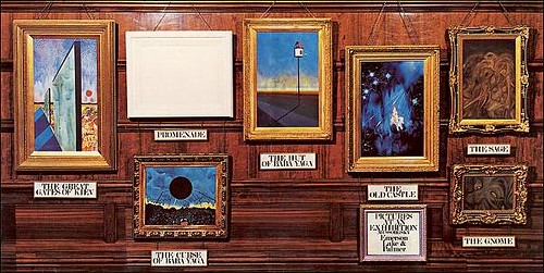
http://www.amazon.com/gp/product/B0000033P1/ref=pd_sim_m_4/102-1182921-5266521?%5Fencoding=UTF8&v=glance&n=5174

The Great Gates of Kiev
(Mussorgsky, Lake - in "Emerson Lake and Palmer" album "Pictures at an Exhibition")
-----------------------

Come forth, from love spire
Born in life's fire,
born in life's fire.
Come forth, from love's spire

In the burning, all are (of our) yearning,
for life to be.
And the pain will (must) be gain,
new life!

Stirring in, salty streams
and dark hidden seams
where the fossil sun gleams.

They were, sent from (to) the gates
Ride the tides of fate,
ride the tides of fate.
They were, sent from (to) the gates

In the burning all are (of our) yearning,
For life to be.

There's no end to my life,
no beginning to my death
Death is life.

Twenty Years After, Plants (part 12 of 12)

IMG_3982

IMG_3958

At the end of 1986 a "sarcophagus" was erected in Chernobyl reactor 4 over bags of sand and lead thrown out by helicopter crews.

However those structure is crumbling and the rain get inside, becaming loaded with radionuclides (became "radioactive"). Kiev is downstream, through the Pripyat and the Dnieder Rivers.

(Also the radioactive dust release in the few days after the accident is still contaminating water in Chernobyl and Belorrusia adjacent areas)

Dams have been build to try to stop the water but its success is debated.

Photo 1: This is what is left of Chernobyl reactor 4, that exploded April 25, 1986 (UTC date) or April 26 (local date), 20 years ago today (this is generally the closest a TV crew or photographer can come)

Photo 2: Tow cooling towers (one unfinished)

UPDATE (Coordinates & Satellite Photos - added in 2006-May-31):

Photo 1:

http://maps.google.com/maps?q=&t=k&om=1&ll=51.389646,30.099739&spn=0.002196,0.004694

Photo 2:

http://maps.google.com/maps?q=&t=k&om=1&ll=51.376723,30.131829&spn=0.004447,0.009978


(As ususal, you can change the zoom using the rule near the left margin and/or pan using the left click of the mouse)

Twenty Years After, Wild Horses (part 11 of n)

IMG_3948

IMG_3948zoom

IMG_3951

Chernobyl area has became a animal reserve. With human population at a very low level, animals (and plants) seem to be recovering very well.

Photo 1: Wild horses

Photo 2: (Digital) blow-up of photo 1

Photo 3: Russian video crew (working for a japanese TV network)

UPDATE (Coordinates & Satellite Photos - added in 2006-Jun-04):

The place where I was, when I took photo1:

http://maps.google.com/maps?f=q&hl=en&q=51.227150,+30.141783&ll=51.227189,30.142531&spn=0.001448,0.005364&t=k&om=1

UPDATE (Coordinates & Satellite Photos - added in 2006-Jun-05):

The picture 3 was taken near the point

http://maps.google.com/maps?f=q&hl=en&q=51.27357,+30.21960&ll=51.273605,30.219601&spn=0.001446,0.005364&t=k&om=1


(the large building was the place were we hold the meetings, change to "radiations cloths" and where I had lunch that day. It is also the headquarters of the administration of the "Chernobyl Area")

Tuesday, April 25, 2006

Twenty Years After, Instruments (part 10 of n)

IMG_3977

IMG_3999

In Chernobyl area instruments to measure radiation are popular. Most are Geiger type detectors and a lot use a classical "click, click, click..." audio warning, usually along with a numerical display.

Likely they all measured "absorbed dose" which is the easy to measure. I believe that all the instruments I saw were measuring the dose in rad/hour (the russian word for "hour" looks like "4AC", with a "4" open in the upper part as usual in "4" draw by hand - (we can see that word on photo 1).

Roentgen/Hour is a obsolete term that means more or less the same.

Photo 1: Observation room. Absorbed dose = 1.23 rad / hour (?). Probably the sensor was on the building but outside.

Photo 2: Downtown Pripyat (counter in close contact with the mud). Absorbed dose = 1.264 rad / hour (?). Out of the mud the dose halved.

Other photo of a similar intrument in the exact same spot:

http://www.neatorama.com/2006/03/29/ghost-town-chernobyl-photoblog-by-elena-filatova/


Those value are generally considered "very high radiation area" the higher possible classification when dealing with nuclear security. However those values are not particularly useful to access risk. I explain.

First, the values of the "absorbed dose" should change very rapidly from point to point, so a few "hot spots" are not dangerous if rare.

Second, the main danger comes from radionuclide we inhale for the environment and from dust we collect with our body (mainly by our hair, beard, nails), that can later irradiate our body from inside (i.e. at very close range).

Added in 2006-May-25: I think that some TV crews mistakenly took my GPS for a sort of "radiation meter" so they film it a lot :-)

UPDATE (Coordinates & Satellite Photos - added in 2006-May-31):

Photo1:

http://maps.google.com/maps?q=&t=k&om=1&ll=51.391179,30.095249&spn=0.001667,0.004989

UPDATE (added in 2006-Jun-2):

Photo2:

http://maps.google.com/maps?q=&t=k&om=0&ll=51.407652,30.055214&spn=0.004444,0.009978

Advance topics:

All the instruments I've seen measured the "radiation" in rad/hour (although they should be using the SI unit gray/second, i.e. Gy/s).

1 Gy = 1 J/kg = 1 m2·s–2 = 100 rad

Try not confuse with "dose equivalent" (in rem/hour, SI: sievert, 1 Sv = 100 rem). Of course they have the same dimensions and, in some cases, similar values.

Rem/hour are probably more useful but more difficult to measure.

Twenty Years After, at the observation room (part 9 of n)

IMG_3974

IMG_3969

The "observation room" is the closest point we could approach the reactor 4 (the one that exploded in 1986) if we are not doing something important that needs a closer visit.

I would probably not consider going further without protecting my face, shave and using a mask in my mouth to filter the air before breading. But the observation room is closed and regularly sweep to give us some extra protection from dust. Also the wall would stop same (most?) beta radiation and hopefully some gamma too.

We were not allowed to take pictures of the reactor from there probably because we could spot security measures against an anauthorized access.

It was possible to take picture in the observation room of the room itself, but not of the reactor from the room.

Photo 1. In the wall, flags of countries (and organizations) that are helping the Chernobyl clean-up (they are also learning how to deal with a similar problem... or with a dirty-bomb attack).

Photo 2: Projected arch (container) to seal all the reactor 4. (the actual structure is crumbling).

Those 2 photos were taken inside the "observation room" at the point:

http://maps.google.com/maps?q=&t=k&om=1&ll=51.391179,30.095249&spn=0.001667,0.004989

Saturday, April 22, 2006

Twenty Years After, Pripyat (part 8 of n)

IMG_3996

IMG_4007

IMG_3983crop

Those pictures were taken inside Pripyat (also called Atomgrad) , a small town where 50000 inhabitants live before the Chernobyl accident.

Now, since nobody lives where, the town is slowing decaying, and is probably the most know landscape of the "area I".

http://www.pripyat.com/en/

Although the bus shown has had better days, it was our mean of transportation inside Pripyat.

Can you spot the sign on the building wall (by the street lamp)? "pripyat.com".

For more pictures of Pripyat, see my previous post:

http://lasers-in-the-jungle.blogspot.com/2006/04/twenty-years-after-nobody-lives-here.html

UPDATE (Coordinates & Satellite Photos - added in 2006-Jun-2):

Photo1:

http://maps.google.com/maps?f=q&hl=en&q=51.405484,30.058519&ll=51.405484,30.058519&spn=0.003333,0.013475&t=k&om=1

UPDATE (Coordinates & Satellite Photos - added in 2006-Jun-06):

Photo2:


http://maps.google.com/maps?f=q&hl=en&q=51.40612,+30.06460&t=k&om=1&ll=51.406156,30.064602&spn=0.001442,0.005364

Twenty Years After, enterring "zone I" (part 7 of n)

IMG_4009

Re: map

IMG_3955

This building (first picture) is probably the most important building in Chernobyl (city). This is usually the place where visitors put protective cloths on before entering "zone I" and where must briefings take place.

If you are wondering what is written in the suits: "pripyat.com".

(a quick note about the protective cloths: I do not believe that those protective cloths were that important if you are going to stay just a few ours a day along a week or so in the "area I". I also believe that the most sensitive parts to protect are the hair, the beard and hand nails, that can collect dust).


UPDATE (Coordinates & Satellite Photos - added in 2006-Jun-06):

The pictures were taken near the point

http://maps.google.com/maps?f=q&hl=en&q=51.27357,+30.21960&ll=51.273605,30.219601&spn=0.001446,0.005364&t=k&om=1
(the large building was the place were we hold the meetings, change to
"radiations cloths" and ... where I had lunch that day. It is also the
headquarters of the administration of the "Chernobyl Area"

Friday, April 21, 2006

Twenty Years After, The zones of Chernobyl: Chernobyl plant, Chernobyl City, Pripyat, 10km zone and 30 km zone (part 6 of n)

IMG_3945

map

Around Chernobyl (the nuclear plant n. 4) a "alienation" zone (aka"exclusion zone" aka "controlled area"aka "30 km zone") has been created.

http://en.wikipedia.org/wiki/Zone_of_alienation

The alienation zone includes a circle of 30 km around the nuclear plan but extends further into the West.

Specials laws, and by-laws, are applied to this area and nobody can legally enter without a specific permission, asked and given inadvance.

Entering the zone people must show a identification document (the passport if you are a foreigner). In the way out people must be submitted to a brief radiological exam.

(

In a previous post I show the point where I have entered thealienation zone and a college been submitted to radiological exam in the way out.

http://lasers-in-the-jungle.blogspot.com/2006/04/twenty-years-after-inout-part-4-of-n.html
)

In the alienation zone all economic activity is prohibit, except if itis related to the management or study of the Chernobyl accident and its effects, or somehow support those activities. People that work outside the buildings must wear protective cloths, although in some cases the protection only covers the hair.

The maps of this area can sometimes difficult to understand because theUkrainian rule only applied in Ukrainian territory and the Belarus border is, in theNorth and Est, less than 30 km from the reactor.

The alienation zone is divided in several sub-zones. The "zone I" is the inner sub-zone, roughly 10 km around the reactor but extending further to the West, in some places to around 50 km.

Nobody is allowed to live there, but some people work there. (the exact number and size of the different zones has changed withtime, but the "30 km alienation zone" and the "10 km inner zone" have always been the base of any zoning).

Chernobyl (the city) is near the border of the "Zone I", but outside,at around 15 km from the plant, so people live there.

The most know city inside the zone I is Pripyat, a city build recently to lodge the workers at the plant, before the accident. Pripyat is now completely abandoned since it is inside "zone I"

http://en.wikipedia.org/wiki/Chernobyl

http://en.wikipedia.org/wiki/Pripyat,_Ukraine.

http://pripyat.com/en/

http://pripyat.com

For people that is going to stay outside, for long, in the "zone I",it is recommended to use protective cloths covering most of the body.

Photos: I took this pics entering the alienation zone at the passport control point. It shows the alienation zone and sub-zones - TheUkrainian the word for "zone" looks like "3OHA".
The map extends only to Belarus border (in the North andEst), what is understandable, since it
only coverts territory underUkrainian jurisdiction, but sometime this is misleading about the dimension of the tragedy.

In the placard we can also see the a list of several parameters in the different sub-zones.

UPDATE (Coordinates & Satellite Photos - added in 2006-Jun-4):

The point where I enter (and left) zone III:

http://maps.google.com/maps?f=q&hl=en&q=51.117867,+30.122217&t=k&om=0&ll=51.118448,30.122194&spn=0.023221,0.085831

The pictures shown here were also taken in the same place

Monday, April 17, 2006

Twenty Years After, nobody lives here (part 5 of n)

Exclusion zone (nobody is allowed to live here since the Chernobyl explosion)

IMG_4003

IMG_4000

UPDATE (Coordinates & Satellite Photos - added in 2006-Jun-06):

Pictures 1 were taken near the point

http://maps.google.com/maps?f=q&hl=en&q=51.40590,+30.06355&t=k&om=1&ll=51.405936,30.06355&spn=0.001442,0.005364

UPDATE (Coordinates & Satellite Photos - added in 2006-May-31):

2nd Photo:

http://maps.google.com/maps?q=&t=k&om=0&ll=51.408439,30.055676&spn=0.001666,0.004989

Twenty Years After, in/out (part 4 of n)

In / out

photo 1: Going inside the controlled area


IMG_3947

photo 2: radiological check, going out of the controlled area

IMG_4029

Sunday, April 16, 2006

2 kiev postcars

photo 1: Kiev main (Orthodox) church.

IMG_3748

photo 2: downtown Kiev with in good Saturday evening (with a lot of
players, mosttly rock)

IMG_3772


UPDATE (Coordinates & Satellite Photos - added in 2006-May-31):


Photo 1:

http://maps.google.com/maps?f=q&h
l=en&q=50.455646,30.522889&ll=50.455646,30.522889&spn=0.001701,0.006738&t=k&om=1


Photo 2:

http://maps.google.com/maps?f=q&hl=en&q=50.44656,30.521752&ll=50.44656,30.521752&spn=0.001472,0.005364&t=k&om=1

Saturday, April 15, 2006

Friday, April 14, 2006

Twenty Years After, the future of mankind (part 3 of n)

IMG_3679

Yesterday I went to a talk about "Climate and human changes: Past and Future", speaker Mr. Jonathan Cowie (England). An environment scientist, I have been told.

At the end I asked him, are you ready to take the final conclusion to your speech and to say, and to say here in Ukraine, that the nuclear energy is the only solution? He grimed at me.

The picture: My room


UPDATE (Coordinates & Satellite Photos - added in 2006-May-31):

My hotel:

http://maps.google.com/maps?f=q&hl=en&q=50.432173,30.518196&ll=50.432173,30.518196&spn=0.001702,0.006738&t=k&om=1

Thursday, April 13, 2006

My first time in Kiev

For 24 hours in Kiev (aka Kyiv) now, and I haven't had a decent meal yet. OK I am not going to starve because I bough some chocolate bars and cheese slices at local late hour grocery stores together with bottled water (could not find any bread).

The closed I got to a decent meal was at a Chinese restaurant (Ukrainian version / NO chopsticks).

Is dificult to use "clasical" restaurant due to the lack ao any indication I could read.

A slot of street vendors sell very fatty and not particularly tasty food.

The hotel restaurants have a menu I can not understand, and no buffet, not even for breakfast.

The room itself is OK, much better that I would have expected for an hotel belonging to the Ukrainian ministry of the young and sports.

SAT+cable TV with at least one understandable channel (BBC news).

The bathroom is OK, but without soap (or shampoo). From the 14th floor I can see a LARGE stadium. I believe the hotel is mainly used by players and there are always a lot of security people in the hall and corridors.

No problems getting local currency with my visa card (Cash advance) at local machines. I hear, however, about problems with foreigners bank cards. The dollar is happily accepted everywhere, but not the euro (what does not make any economical sense, is probably a more profound felling).

At the conventions things stated well with a couple of government ministers talking to an enthusiastic and largely Ukrainian audience.

No Internet station (let alone wireless network) but I've found a nice store that sell relatively fast Internet access by the hour. Their computer even have a USB cable to connect my gadgets :-)

Monday, April 10, 2006

Twenty Years After, Tarkovsky (part 2 of n)

stalker-chernobyl

If you think science fiction films in the former USSR Tarkovsky in the film director you can not miss.

Tarkovsky was of course the director of "Solaris", by the time Stanly Kubrick was directing "2001", but also the director of "Stalker" in the early 80's.

"Stalker" is the summit, in sci-fi movies, of Russian way to tell things, as in literature we have "doctor jivago" and "war and peace".

Stalker is loosely based on a book of the Strugatsky brothers, but the main point of interest today is the, real or imagined, connexion between the film and the Chernobyl accident, 6 years after the film was produced.

In some cases the cases the coincidence was forced when the nomenclature of the film was applied to the situation after the 1986 accident. But a lot of people see in the movie a (grim) anticipation.

However the most amazing thing is that - I read - the last scenes of Stalker where shoot with Chernobyl in the background.

UPDATE:

in

http://en.wikipedia.org/wiki/Chernobyl_zone

we can read "In a bizarre coincidence, the movie itself ends on a shot of the Chernobyl power plant taken before the 1986 explosion"

in:

http://www.kamera.co.uk/reviews_extra/stalker.php

we can read "During the film [Stalker] Revelation 8:7-11 [Bible] is eerily read: The third angel blew his trumpet; and a great star shot from the sky, flaming like a torch; and it fell on a third of the rivers and springs. The name of the star was Wormwood; and a third of the water turned to wormwood, people in great numbers died of the water because it had been poisoned"

More:

http://maps.google.com/maps?q=&t=k&ll=51.387222,30.111389&spn=0.048742,0.1157

http://en.wikipedia.org/wiki/Liquidators

http://en.wikipedia.org/wiki/Zone_of_alienation

http://en.wikipedia.org/wiki/Stalker

http://en.wikipedia.org/wiki/Chernobyl_accident

Saturday, April 08, 2006

wireLESS


wireLESS
Originally uploaded by lasers-in-the-jungle.

A few weeks ago, during the week end, I lost my dial-up Internet

access (anyone noticed?).


After a walk I found the point where the cable was cut. I sent the

coordinates to the phone company, but apparently they do not have any

GPS and ignored the meaning of the words "coordinates", "latitude" and

"longitude".